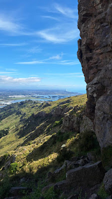
Time: 2 hours and 20 minutes
Distance: 4.62 km
Start: Rockview Place, Mt Pleasant.
Finish: Same place, it's a loop
Date: Friday 22nd November 2024
Warning: The track below the crags goes through rockfall zones
Kenton Track - from Rockview Place up to Summit Road - is a pretty tame Port Hills meander, but about 15 minutes in, there is a nifty unmarked side track that runs down under the bluffs between Britten Crag and Cattlestop Crag. A rockclimber's access track, and (I reckon) probably one of the more adventurous tracks in the Port Hills. With boulders perched precariously in high places, you probably wouldn't want to linger here in an earthquake. There is in fact a "Track Closed" sign at the Cattlestop Crag end. Not much good if you are accessing the track from the Britten Crag end. Which we did today.
This is definitely rock climbing territory. But the path is good and works its way haphazardly under the bluffs all the way past Britten Crag to Cattlestop Crag. The crux (for us) was a scramble down some rock with strategically placed metal hand- and foot-holds. I shimmied forward on my butt and the others more or less followed suit.
Every now and then the track would branch and we mostly chose
whichever option kept us as close as possible to the bluffs. On the vertical rock faces, the
bolts and chalk marks from climbers could be seen. There were a few impressive caves to check out and we also hopped our way across a couple of rock falls.
We popped out from Cattlestop Crag at the stone memorial seat of former landowner John Somerville Scott (and - subplaque - his wife Millicent Jean Scott). A spider was crossing Summit Road as we passed by. We decided to follow the parallel (to Summit Road) mountain bike track to the spur, at which point we intersected with Kenton Track again. We descended the spur on Kenton Track through the John Britten Reserve to the corner of Longridge Drive and Clearview Lane. Apt street names. From here we worked our way back, through the flash subsivision, to the car.


