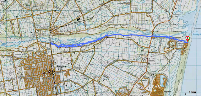
Time: 3 hours
Distance: 24 km (12 km each way)
Start: End of Rotten Row, Waikuku Beach Estuary
Finish: Same place (it's there and back)
Date: Friday 27 September 2024
Times: Waikuku Beach to Rangiora Railway Bridge (East Belt) 1.5 hrs, 30 minutes stop, 1 hour back)
The Ashley/Rakahuri River has origins in the Puketeraki Range of the Canterbury Foothills. It winds its way through the narrow Ashley Gorge, then braids across the Canterbury Plains, before exiting the coast via the estuary at Waikuku Beach. The river is a wāhi taonga (treasured place) and traditional mahinga kai (food gathering area) for local Ngāi Tahu hāpū, Tūāhuriri. Extensive flood mitigation and farming has modified and polluted the river since European arrival. Nowadays the area is part of the Rakahuri Regional Park - managed by Environment Canterbury and Mahaanui Kurataiao Ltd.
The Rakahuri Trail, one of the Waimakariri Eastern Cycle Trails, runs from the coast, heading inland along the southbank of the river, and today we were riding the eastern section from Waikuku Beach to the Rangiora railway bridge (and back). It's a 35 minute drive from Ōtautahi to Waikuku Beach. We were a bit distracted, catching up on all the goss of the past week, and hence missed a crucial turn-off. This resulted in a double circumnavigation of a roundabout - an exercise which never fails to put a smile on one's dial.
The trail starts at the Waikuku Estuary, somewhere near the end of Rotten Row. The tide was low and pukekos were bobbing about, looking positively prehistoric. A bit of pfaffing around to extract the bikes, then we were soon pedalling west along the wide stopbank, crossing the stream over a small bridge decorated with painted whitebait-themed pebbles.
The Rakahuri Trail is well maintained, mostly oneway with good signage and we were soon scooting down a small side track, off the stopbank and into the trees. It's an easy trail, however I tend to generally ride a bike in a haphazard fashion - stopping without warning or crashing into the foliage. Because Carolien has been on a bike since she was a tot, she took the lead, weaving with expertise along the windy, undulating path. Rabbits and birds darted this way and that in front of us.


