Time: 3 hours and 30 minues (includes a lengthy morning tea)
Distance: 5.3 km
Start: Bridle Path car park, Bridle Path Road
Finish: Same place (it's a loop)
Date: Friday 16th August 2024
Bridle Path car park 9am. A sterling turnout today (sans leather glove). With walking poles click-clacking like mad, we set off pronto - up the path for a meer 5 minutes or so, before turning left onto an obvious - but unmarked - side track. A locked farm gate stopped us in our tracks. No signage. I think I caught a few unsettled mutterings as I hastily climbed over. This path has been technically closed since the 2011 earthquakes due to rockfall danger from the buffs above. It took some jollying along on my part, but eventually we all managed to either climb over the gate or squeeze through the fence somehow.

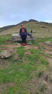
Once over this obstacle, there is a good track, once called the Morgan's valley sidle path, that runs along (the wrong side of) a protective fence, under the gondola and around the contour line. The fact that the fence has captured a few boulders over the years did not go unnoticed by our perspicascious party. At the wooden memorial seat, a right-hand turn onto yet another unmarked track took us straight up the grassy spur to a rocky outcrop. Pickering's Peak apparently. The terrain looked steep but was easier going that expected and there were plenty of stops to catch the breath and admire the views.
From the outcrop, the track wound its way up to Summit Road through red volcanic rocks. The wreckage of a car could be seen in the valley below. We took photos and zoomed in. It looked like it could have tumbled 100 meters from the road above us. Perhaps recently? The photos were too blurry to tell for sure. I meant to ring the police afterwards - but unfortunately I forgot.
We popped out onto Summit Road directly under a spectacular example of a
volcanic dyke (or is it dike?), where liquid magma flows up through a fissure in existing rock. A gentle reminder that the Port Hills are the remnants of a volcano complex that exploded about 11 - 6 million years ago. I only recognized the rocky protrusion as a dike when I saw the photos later on. We walked obliviously east along Summit Road (no cars here) for about five minutes to where there is a cattle stop and a number of track junctions.

From various options, we chose the steep, wide, grassy track straight up the hill to the top of Mount Cavenish and the gondola edifice. According to
Kā Huru Manu (the Ngāi Tahu mapping project) the hills above Lyttelton Harbour/Whakaraupo, including Mount Cavendish, are called Ōketeupoko ("Basket of Heads"). Named after a decisive victory by the invading Ngāi Tahu over the resident Ngāti Mamoe, and the subsequent placement of some victims heads in a kete (basket) on a rocky crag in the vicinity.
We lingered over coffee and date scones at the Gondola Cafe. We were here a couple of years ago and I'm pretty sure we got the same staff member serving us today. The plate with the date scones came swiftly towards us, and was deposited on the table with a stoney silence and an unceremonious thud. We looked at each other with shocked expressions and then returned to our wonderful conversation about the travels of our youth.
We took the walkway back to the
Canterbury Pioneer Women's Memorial ["
On this spot the pioneer women of Canterbury and their families rested after their climb from the port of Lyttelton and gazed with awe but with courage upon the hills and plains of Canterbury where they were to make their homes"]. It was a quick scuttle down the steep bridle path. Apparently the effects of the gradient can be eased by leaning back slightly and tucking your bottom inwards.


