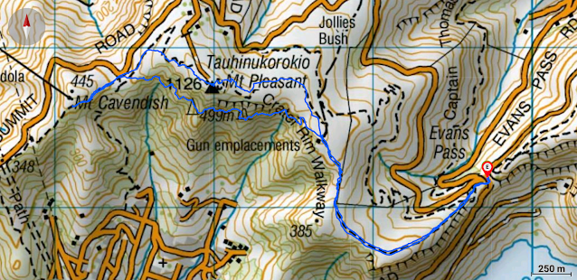
Time: 3 hours and 10 minutes (1.5 hours from Evan's Pass to Mt. Cavendish; 1 hour and 40 minutes return via Mt. Pleasant Bluff's track.)
Distance: 8.4 km
The 20 km Crater Rim Walkway (CRW) goes all the way from near Gebbies Pass to Godley Head, sidling along the edge of the now extinct Lyttelton Volcano. This volcano complex was formed 11-6 million years ago (pretty specific) and Lyttelton Harbour is what is left of the crater. Our plan is to walk it in six sections (see below), today being section five.
CRW 1: Ahurihi bush to Sign of the Bellbird
CRW 2: Sign of the Bellbird to Sign of the Kiwi
CRW 3: Sign of the Kiwi to Mt. Vernon
CRW 4: Mt. Vernon to Mt. Cavendish
CRW 5: Mt. Cavendish to Evan's Pass
CRW 6: Evan's Pass to Godley Head
It's actually much more convenient to walk this section in reverse so we parked at Evan's Pass and launched into our ascent of Mt. Pleasant. It was an absolute corker of a Christchurch winter's day. The fog (or smog) was rolling away and the blue blue sky was flooding our retinae with oodles of happy blue spectrum light.
Still, it was a bit of a shock to be walking uphill after a few weeks on the flats. After about 30 minutes, via some World War II Gun Emplacements and a couple of unexpected barbed wire fence clambers (city girls in action), we were at the Mt. Pleasant Trig with its fabulous 360 degree views. Two runners went by - one bald the other barefoot.
According to Ka Huru Manu, this was once the site of a pā. The māori name for Mt. Pleasant is Tauhinukorokio, after the tauhinu (cottonwood, Ozothamnus leptophyllus) and korokio (Corokia cotoneaster) native shrubs that were once plentiful in the area.
We marched onward towards Mt. Cavendish and the gondola complex. The muddy track meandered hither and thither and so we took an off piste shortcut with no serious consequences. From the saddle it was an easy 10 minute brisk walk up to the junction just below the gondola complex.
We stopped for some serious discussion. Coffee at the Gondola Cafe (not exactly renown for its ambiance, food, coffee or service) or lunch at Sumner. We deemed the latter to be the better option and so turned tail and retraced our steps back to the saddle.
Here the Mt. Pleasant Bluffs Track branches off. This track has been closed since 2011 after the Christchurch Earthquakes but appears to be still frequently used. For one thing, budding ecologists have left a plethora of plastic signage to beware of the moss. For the record, we took photos of the "Track Closed" sign and strode on by. The track sidles on slippery rocks under the bluffs and in and out of the bush all the way up to the Gun Emplacements. This would probably be better in summer but we (kind of) enjoyed the adventure and uncertainty of the path. Shaded from the sun, slightly wild and over grown, each time you grabbed a tree trunk for stability you got a cold shower. Type 2 fun and hopefully we didn't trample any moss. It was lovely to finally be standing in the sun back on the Crater Rim Walkway.
We descended the tussock farmland ridge back to the car park. Sumner was heaving (school holidays) but we managed to get a fortuitous park and a table at the Beach Restaurant where the ambiance, food, coffee and service are all fabulous. Yay!


