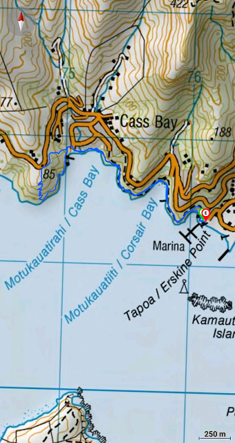
Distance: 5.21 km
Time: 1 hour and 40 minutes
Another wee Christchurch gem: The Lyttelton Coastal Walk winds it's way along the bays to Pony Point Reserve/Otuherekio. You can start in town at the Lyttelton Information Center and make your way to the coast via roads and paths (according to the Rod Donald Trust pamphlet of Lyttelton Walks) or you can drive directly to the Naval Point Yacht club and start from there. We decided on the latter and, with a bit of pfaffing around trying to find each other, we eventually set off on our way.
Overcast and without a breath of wind, our first port of call was over the hill to Magazine Bay. A magazine is a storage building for ammunition (I didn't know this) and there is one in the bay which was built in 1885 in response to the Russian invasion of Afghanistan. This connection seems a bit vague now but I guess times have changed (or have they?). In more recent years the building became the Torpedo Bay Museum and housed parts of an old Torpedo boat the Thornycroft (1883). Is the museum still open? Not obviously. The building looks derelict but a graffitied sign says "Open Sunday 1-3 pm". Might have to check that out.
We actually missed all of this history completely because when we arrived at the bay we turned right instead of left and so didn't notice the building. We also missed the information panel in the middle of the bay. We crossed the beach and clambered back up to the main path and around to Corsair Bay/Motu-kauati-iti. The Corsair was a whaling boat wrecked here in 1861. Motu-kauati-iti means "little fire making tree grove" - a reference to the kaikoimako trees that once grew here (no longer). A block of kaikomako wood could be rubbed with a hardwood stick to make fire. We admired the picturesque view: the tide was in and the council were weed-eating the bay - noisy but the smell of fennel pleasantly pervaded the air. In the weekend apparently teenagers congregate here in droves and swim out to the pontoon. I had my togs with me but...yeah nah.
We ignored the "Track closed" sign and meandered on to the next bay which is Cass Bay/Motu-kauati-rahi ("great fire making tree grove"). Thomas Cass was a surveyor for the Canterbury Association (1817 - 1895). There is a monstrous copper cladded house in Cass Bay which is uncomfortably plonked on the beach and hurts the soul to look at. Must be nice inside though.
We decided to take the not-so-steep track up the hill to Pony Point Reserve/Otuherekio. A dog ran past at high speed, obviously on a mission. About 5 minutes later we came across the owner, a young guy walking towards us carrying a large spade. He asked: "Have you seen a dog?" and when we answered yes he broke into a canter looking stressed. Further up the hill we stopped to discuss what the spade might be for and also what is the difference between kanuka and manuka. The flowers of the kanuka have more small spikelets compared to the manuka ones (Thank you Linda!). At the top of the hill is the Pony Point Reserve/Otuherekio (no ponies to be seen) and we lingered to admire the carved pou and the beautiful views.
The path down through the gum trees is steep and a bit slippy slidey in the dry mud. We descended to the beach to try and find the thermal spring but the tide was too high so no luck. Apparently there are thermal springs (a tepid 20-33 degrees centigrade) on the beach and near the boat shed. I found the beach one once about 15 years ago. These springs are not volcanic but ground waters that are circling from deep in the earth's crust. Others can be found in Rapaki Bay and Motukarara. I came across an old Stuff article about how the water temperatures changed after the Christchurch earthquake.
We retraced our steps along the pathway back to the car park and drove to the Shroom Room Cafe for hot chocolates, coffee's and massive muffins and avocado cheesecake (sounds horrible but was actually delicious). Fat sparrows watched us intently. The sun came out and we wandered around the quirky Lyttelton shops before heading home.


