Time: 2 hours and 15 mins including the return


Distance: 20 km for the loop
Spencer Park to Whites Crossing: 10 km 1 hours and 30 minutes
White Crossing to Spencer Park via Kianga and Lower Styx Road: 10 km 45 minutes.
Start: 100 Heyders Road, Spencer Park, Spencerville
Finish of section: Whites Crossing car park (we returned via roads)
Date: Friday 3rd August 2020
Updated: May 2026 - the track is now in much better condition than that described below. It is also mostly well sign-posted - but it's still useful to have the track description handy!!

We met at the Spencer Park car park. Specifically this is on the corner of Hayder Ave and that tiny road with no name where the campgound is. The plan: cycle the Brooklands Mouth Section of the Christchurch360 Trail. The Christchurch360 Trail circumnavigates Christchurch city and is still work in progress and currently a little short of 360 degrees. Perhaps you have seen the logo when you are out and about?


Well, I have too but try as we might, there was no sign of it at the Spencer Park car park (perhaps we should have gone further down the road). Luckily, I had read the track description (and had a Google Map of the route open on my phone) and knew we had to follow the Brooklands Lagoon track. So we unloaded the bikes and set off towards the lagoon. We were soon on a track of sorts and, low and behold, there was a fence post with the tiny logo pointing us in the right direction. Phew.
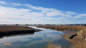
Despite forecasts predicting otherwise, it was an absolutely stunning morning. The lagoon was shimmering like silver in the sun and the Canadian geese, scaup and pukeko were pottering around the lagoon edge en masse. It took us a while to get going proper because after about 5 minutes of riding we came across three pukeko, perched comically (and uncomfortably) on top of a mingimingi bush and so we stopped for photos. I presume their large feet prevented them from crashing through to the ground. As we approached they defied gravity and took off in an ungainly and squawky fashion towards the lagoon.

We loped along, at first on a good gravel track but then half biking, half walking in the sand and mud. I found myself letting out the odd pukeko-like squawk as well on frequent occasions. Bikes appear to suddenly stop when you hit a patch of sand. Actually, to be honest, to call this a bike track is stretching it a bit. More like a sandy walkway - almost impossible to actually ride a bike on. But we persevered and Nicole spotted her first kingfisher.


Eventually we arrived in Brooklands. Once a subdivision, this became red-zoned land after the 2011 earthquakes and has that red-zoned land feel to it. You can still make out the section perimeters and the old telephone boxes sticking up. The odd house is still standing and occupied. Perhaps no insurance or just stubborn owners who refused to leave. I don't blame them.
At this point all trail logo signs disappeared. But we figured (because there was really nowhere else to go) that we should join the stop bank of the Styx River which eventually joins the Waimakariri River. Waimakariri means "cold water" in Te Reo Māori. The cycling was a lot easier along this stretch and we were really zipping along. We passed a lock and a yacht and could see all the way down the river to the alps in the distance. Classic South Island scenery. Beautiful!


After about 30 minutes there was a section of windy forest where I experienced a moment of instability and bruised my mons pubis. This hurt like hell and I thought that a) I might be permanently injured and b) my bike must have surely been designed by a man. But after a couple of minutes the pain subsided and we popped out and under the two big bridges. The second one is State Highway 1, buzzing with traffic, and just after that is the Whites Crossing car park and picnic area which marks the end of this section of the Christchurch360 Trail.
We decided we'd better take a look at the river. I'm pretty sure I spotted the rare and endangered black fronted tern (or perhaps it was the common tern). We biked back via Kaianga and Lower Styx Road. It's amazing how much faster road biking is. Before we knew it we were back at Spencer Park and loading the bikes on the cars.


The final stop was lunch at the Flax Bar and Eatery in Marshlands. Luckily, right next door was the boutique Moutique [update May 2026 - now a bit further down the road] for a bit of well earned retail therapy.
