Time: 4 hours


Distance: 6.54 km
Start: Peak Hill car park, Algidus Road, Lake Coleridge
Finish: Same place (it's there and back)
Start: Peak Hill car park, Algidus Road, Lake Coleridge
Finish: Same place (it's there and back)
Altitude: 1265 m (elevation gain 714 m)
Date: Friday 10th July 2020
Date: Friday 10th July 2020

The stars aligned for our walk today. An absolute corker of a Canterbury day plus a bonus: no ice on the roads. It took us 1 hour and 50 minutes to drive from my front door in South New Brighton to the Peak Hill car park with the DOC sign on Algidus Road near Lake Coleridge. This is a popular Christchurch day trip and there were already a couple of cars parked.

Once you climb the turn-style and follow the poles across the paddock, the first hilly section of the walk is a bit of a shock to the system. Straight up with ice underfoot. Because we were huffing and puffing and almost bent over double with this steepness, we could inspect the ice fairly closely. I'm sure these weirdly frozen mud stalks must have a name. [Author's note: "Needle ice"].


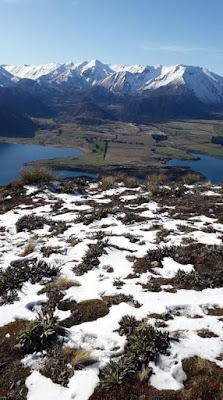
After 30 minutes we were on the ridge and out of the icy shadow. Happily, we shed out puffer jackets and enjoyed the sun and the first of a series of stunning views. Lake Coleridge -indigo blue, the various tans and browns of the alps and a topping of white snow, all under the clearest bluest azure sky you have ever seen. Magic.

Other walkers were passing us, all from overseas. English, Irish, Taiwanese - we knew their life history because we subjected each one to a quick interview (thanks Jane!!). I thought all the tourists had left at the beginning of lock down but here they all were, so happy to be in New Zealand and especially to be on Peak Hill today.

It was now a straightforward amble (well kind of) following the pole markers up to the summit where we were greeted with the open expanse of the Arrowsmith Range and the mighty braided rivers Rakaia, Mathius and Wilberforce. In the distance we could see across to the Algidus high country station where Mona Anderson spent 30 years from the 1940's and wrote about it in "A River Rules my Life'.

The cameras and cell phones emerged and a photographing frenzy ensued. The scenery, us and quite a few tourists were photographed in various combinations. Then the tough descent began. It took about 1.5 hours to return to the car. The last bit is particularly steep and the knees were beginning to complain. We scraped the cow shit off our boots and compared Spaniard Grass pricks. Surprisingly this ubiquitous alpine plant is a native (Taramea meaning 'rough spiny thing') and it has been speculated that it evolved those dreadful spikes as a result of Moa grazing. A bit of a drastic response I feel. Nursing our wounds we jumped into the car and headed straight to the Hororata Village Cafe for pies and flat whites. Yum!


Postscript: When is a hill not a hill? According to definition, Peak Hill should actually be a mountain. "A mountain is a natural elevation of the earth's surface rising more or less abruptly to a summit and attaining an altitude of more than 610 meters". So we climbed a mountain. Yay! Thank you Linda for clarifying that!!